I have the idea there is no clear explanation of the NAO. It is something the word’s navies are even uncertain about. For me the change came with a quake I once tried to forecast on Reddit. Ir should have been a Magnitude Seven but it was a lowly Mag six and I was embarrassed about it, even though nobody had ever forecast a quake online as far as I knew.
For a long time after that I noticed there was a distinct lack of earthquakes in the region of 7M. and over. I attributed the lowering of the magnitudes to the periodicity of the North Atlantic Oscillation.
In other words when the North Atlantic stops the Planet having extra large earthquakes we are in for a dettled Period that is only broken by a very massive volcanic upheaval. I expect that this was the eruption at Tonga: Hunga Tonga–Hunga Haʻapai in 2022.
From Wikipedia, the free encyclopedia
| 2022 Hunga Tonga–Hunga Haʻapai eruption and tsunami | |
|---|---|
| Satellite animation of the initial ash plume and shockwave on 15 January 2022 | |
| Volcano | Hunga Tonga–Hunga Haʻapai |
| Start date | 20 December 2021[1][nb 1] |
| End date | 15 January 2022[1] |
| Type | Surtseyan, Plinian[3][4] |
| Location | Pacific Ocean, Tonga 20.550°S 175.385°W 20.550°S 175.385°W |
| VEI | 5–6[5] |
| Impact | 7 dead, 19 injured, and others reported missing. $182 million in damages in Tonga[6] |
In December 2021, an eruption began on Hunga Tonga–Hunga Haʻapai, a submarine volcano in the Tongan archipelago in the southern Pacific Ocean.[7] The eruption reached a very large and powerful climax nearly four weeks later, on 15 January 2022.[8] Hunga Tonga–Hunga Haʻapai is 65 kilometres (40 mi) north of Tongatapu, the country’s main island,[9] and is part of the highly active Tonga–Kermadec Islands volcanic arc, a subduction zone extending from New Zealand to Fiji.[10][11] On the Volcanic Explosivity Index scale, the eruption was rated at least a VEI-5.[1][12] Described by scientists as a “magma hammer”, the volcano at its height produced a series of four underwater thrusts, displaced 10 cubic kilometres (2.4 cu mi) of rock, ash and sediment, and generated the largest atmospheric explosion recorded by modern instrumentation.[8]
The eruption caused tsunamis in Tonga, Fiji, American Samoa, Vanuatu, New Zealand, Japan, the United States, the Russian Far East, Chile and Peru. At least four people were killed, some were injured, and some remain possibly missing in Tonga from tsunami waves up to 20 m (66 ft) high. Tsunami waves with run-up heights up to 45 m (148 ft) struck the uninhabited island of Tofua. Two people drowned in Peru when 2 m (6 ft 7 in) waves struck the coast, while another died of indirect causes in Fiji. It was the largest volcanic eruption since the 1991 eruption of Mount Pinatubo.[13] NASA determined that the eruption was “hundreds of times more powerful” than the atomic bomb dropped on Hiroshima.[14] The eruption was the largest explosion recorded in the atmosphere by modern instrumentation, far larger than any 20th-century volcanic event or nuclear bomb test. It is thought that in recent centuries, only the Krakatoa eruption of 1883 rivalled the atmospheric disturbance produced.[15][16]
I am not getting involved with subduction zones, suffice to say I can not agree with Weggener or anything of the sort of science these so called scientists teach. If they were any good at their jobs they would be able to forecast earthquakes by now. I had noticed that som earthquakes had since then began hitting the top range or magnitudes but I never gave it any thought. I shall now take a look at things. to make sure I can still do my job. It would be nice to retire but I can’t see it happening.
Magnitude 7 earthquakes since December 2020
| Magnitude | 2010 | 2011 | 2012 | 2013 | 2014 | 2015 | 2016 | 2017 | 2018 | 2019 | 2020 |
|---|---|---|---|---|---|---|---|---|---|---|---|
| 8.0–9.9 | 1 | 1 | 2 | 2 | 1 | 1 | 0 | 1 | 1 | 1 | 0 |
| 7.0–7.9 | 23 | 19 | 14 | 17 | 11 | 18 | 16 | 6 | 16 | 9 | 9 |
| 6.0–6.9 | 151 | 187 | 117 | 123 | 143 | 127 | 131 | 104 | 118 | 135 | 112 |
| 5.0–5.9 | 2,220 | 2,486 | 1,546 | 1,460 | 1,580 | 1,413 | 1,550 | 1,447 | 1,671 | 1,484 | 1,315 |
| 4.0–4.9 | 10,138 | 13,129 | 10,955 | 11,877 | 15,817 | 13,777 | 13,700 | 11,544 | 12,782 | 11,897 | 12,216 |
| Total | 12,536 | 15,822 | 12,635 | 13,480 | 17,552 | 15,336 | 15,397 | 13,102 | 14,589 | 13,530 | 13,654 |
- 7.073 km SE of Pangai, Tonga2025-03-30 12:18:47 UTC29.0 km
- 6.6central Mid-Atlantic Ridge2025-03-28 17:17:27 UTC12.5 km
- 6.7Burma (Myanmar)2025-03-28 06:32:04 UTC10.0 km
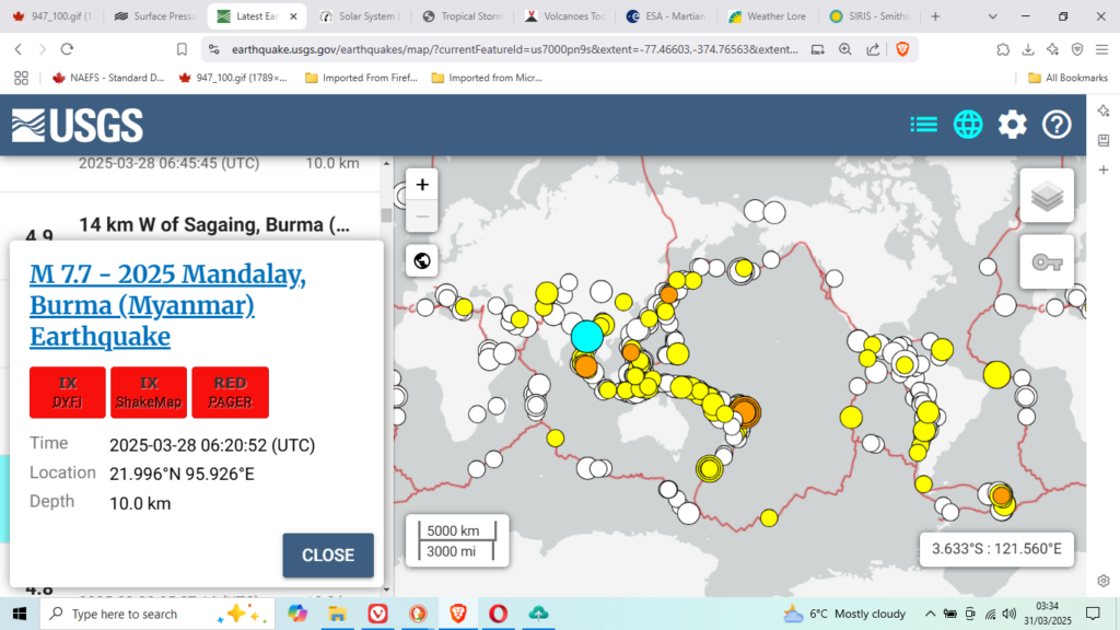
- 7.72025 Mandalay, Burma (Myanmar) Earthquake2025-03-28 06:20:52 UTC10.0 km
- 6.7164 km WSW of Riverton, New Zealand2025-03-25 01:43:12 UTC21.0 km
- 6.5111 km SE of Burica, Panama2025-03-21 14:50:56 UTC10.0 km
- 6.2120 km SSE of Burica, Panama2025-03-21 14:50:51 UTC10.0 km
- 6.536 km NNE of Olonkinbyen, Svalbard and Jan Mayen2025-03-10 02:33:14 UTC10.0 km
- 7.6208 km SSW of George Town, Cayman Islands2025-02-08 23:23:14 UTC10.0 km
- 6.010 km NE of Yujing, Taiwan2025-01-20 16:17:26 UTC16.0 km
- 6.815 km SE of Miyazaki, Japan2025-01-13 12:19:32 UTC39.0 km
- 6.218 km SE of Aquila, Mexico2025-01-12 08:32:49 UTC39.0 km
- 7.12025 Southern Tibetan Plateau Earthquake2025-01-07 01:05:16 UTC10.0 km
- 6.256 km SSE of La Libertad, El Salvador2025-01-05 17:18:45 UTC46.0 km
- 6.184 km NNW of Calama, Chile2025-01-02 20:43:35 UTC99.0 km
- 4.74 km NW of Cobb, CA2025-01-02 02:34:04 UTC
| Magnitude | 2014 | 2015 | 2016 | 2017 | 2018 | 2019 | 2020 | 2021 | 2022 | 2023 | 2024 |
|---|---|---|---|---|---|---|---|---|---|---|---|
| 8.0–9.9 | 1 | 1 | 0 | 1 | 1 | 1 | 0 | 3 | 0 | 0 | 0 |
| 7.0–7.9 | 11 | 18 | 16 | 6 | 16 | 9 | 9 | 16 | 11 | 19 | 10 |
| 6.0–6.9 | 143 | 127 | 131 | 104 | 118 | 135 | 111 | 141 | 117 | 128 | 89 |
| 5.0–5.9 | 1,580 | 1,413 | 1,550 | 1,447 | 1,671 | 1,484 | 1,315 | 2,046 | 1,603 | 1,637 | 1,411 |
I have learned something I had not known, I suppose I should be content with that. Anyway since the canaanites began calling fire out of heaven and used it on the Branch Davidians under Bill Clinton at Waco Texas, in fact since the democrats began using nuclear weapons against mankind in the 1940’s anything Teslaesque such as the Huchison Effect is beyond archival reckoning, weatherwise.
Perhaps I should look for data earlier but the sciences of Seismic measuring was pretty hit and miss under earlier calibrations. Talking about Tonga:
5.3M. 54 km SSE of Pangai, Tonga 2025-03-30 21:51:45 (UTC)
4.8M. 93 km SE of Pangai, Tonga 2025-03-30 19:30:26 (UTC)
4.8M. 92 km SE of Pangai, Tonga 2025-03-30 16:10:09 (UTC)
5.8M. 86 km SE of Pangai, Tonga 2025-03-30 15:33:48 (UTC)
4.9M. 82 km SE of Pangai, Tonga 2025-03-30 15:26:16 (UTC)
6.2M. 85 km SE of Pangai, Tonga 2025-03-30 15:04:54 (UTC)
4.8M. 60 km ESE of Fangale’ounga, Tonga 2025-03-30 14:58:46 (UTC)
4.8M. 90 km SE of Pangai, Tonga 2025-03-30 14:24:44 (UTC)
7.0M. 73 km SE of Pangai, Tonga 2025-03-30 12:18:47 (UTC)
And what about the 7.7M. 2025 Mandalay, Burma (Myanmar) Earthquake; 2025-03-28 06:20:52 (UTC)
Where do you think Mandalay is?
Right on top of Banda Atjeh:

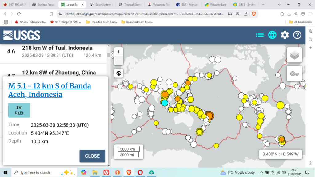
Small word is it not?